the 40th Parallel
Bruce Myren
Friday, October 7, 2005 to Saturday, November 19, 2005
Laconia Gallery presents the landscape photography of Bruce Myren in a solo show, Saturdays from October 8-November 19, 2005. On display in the gallery will be selections from Myren’s long-term project titled ȁThe 40 th Parallel.” Open for both “First Friday” events in October and November, the gallery, located at 433 Harrison Avenue, directly across from the South End galleries, is open every Saturday 1-5pm and by appointment.
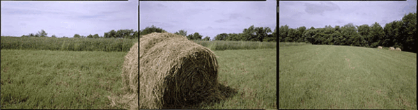
Myren has been photographing the 40th degree of latitude across the United States at every whole degree of longitude. This on-going series addresses several “histories”—his longstanding interest in mapping, the history of the settlement of the US and photography’s role within it, and the history of GPS and new technologies. Spurred by his fascination with the human desire to create and then locate themselves within a system, Myren has visited 15 intersections to photograph his unique three-part panoramas. The gallery will have 10 of his large-scale,14 x 52 inch, color archival ink jet prints on exhibit.
About the 40th parallel
The line N 40°00’00” practically bisects the county and runs from the New Jersey shoreline through Pennsylvania, Ohio, Indiana, Illinois, Missouri, becoming the border of Nebraska and Kansas, and then traversing Colorado, Utah, Nevada, and finally ending in Northern California. To locate the intersection of the 40th and each degree, approximately 53 miles apart, Myren uses a hand-held GPS unit. At each confluence, there is an approximately 20 square foot area in which Myren is able to work and compose a view with his large-format 8×10 antique Deardorf view camera. There are 50 longitudinal points that intersect the 40 th on land plus two coastal points.
Historically, this line has wide-ranging importance. In 1867, native New Englander Clarence King, who later became the first director of the US Geological Survey, charted part of the 40 th parallel, accompanied by photographer Timothy O’Sullivan. King’s survey was one of the many 19 th century survey projects in the American west undertaken by the government for the purposes of western expansion and the railroad. Coincidentally, US 40 happens to weave in and around the parallel from Ohio across the west.
About Bruce Myren
A graduate of Massachusetts College of Art, Myren started his photographic career at age 16 with a job at his hometown newspaper. He has exhibited his work at the Photographic Resource Center and the Floating Gallery, among other venues. Myren currently runs his own digital imaging consulting business, BeeDigital, in which he works on various commercial projects and provides a range of imaging support services.
Read the review of the exhibit: here.